|
 |
|
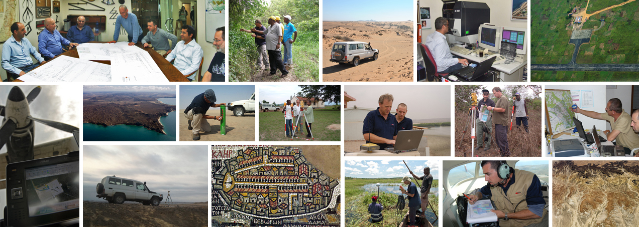
The collection, analysis and presentation of geographical information have always been a strong interest and an important asset for nations and societies. Efficient management and exploitation of Geo-information have continually played a major role in the administration and control of land and property assets, so that more and more resources have been invested in them. The modern era has introduced a vast array of new technologies to the Geo-information field, which have improved the capabilities, sophistication and flexibility of land management methodologies and output.
We at MDVIA believe that only a combination of modern knowledge and a respect for traditional disciplines can succeed in the sphere of Geo-information. Our approach to the world of Geo-information stems from geodesy, mapping, geography and geology, which together with our extensive survey and reconnaissance experience gives us a solid basis to tailor the right solutions for a variety of clients and needs. One of our leading products is the Baobab GIS – a web based system that combines our extensive knowledge and innovative approach, designed to serve companies in the upstream oil and gas industry in projects around the globe.
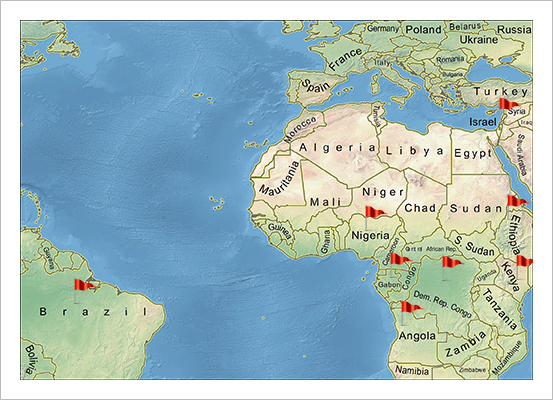
MDVIA offers its customers tools and solutions to perform various projects world-wide. MDVIA, through its companies, has registered success in projects such as:
|
|
 |
|
Geodesy for 2D and 3D seismic projects along with design and implementation of a GIS in Cabinda, Angola. |
|
|
Orthophoto production of 30,000 km₂ in Kwanza basin, Angola. |
|
|
Design and implementation of a GIS center for a 27,000 km₂ seismic project in Kwanza basin, Angola. |
|
|
Orthophoto production of 8,500 km₂ in Namibe, Angola. |
|
|
Design and implementation of a GIS center for an 8,500 km₂ seismic project in Namibe basin Angola. |
|
|
Orthophoto production in the Democratic Republic of the Congo for the upstream oil and gas industry. |
|
|
Orthophoto production in Nigeria for irrigation planning. |
|
|
Orthophoto production in Gabon for various purposes including cadastre, agricultural development and |
|
|
infrastructure planning in a 8 cm per pixel (GSD). |
|
|
Design and implementation of a GIS center for concessions development in Zaire basin, Angola. |
|
|
Reconnaissance mapping and ERW risk assessment on Zaire basin Angola. |
|
|
Commercial escort for seismic project, Ogaden desert, Ethiopia. |
|
|
Instruction on the operation of advanced 3D production software, Kenya. |
|
|
Aerial photography for tree survey purposes , Brazil. |
|
|
Change detection for flood disastrous zones, Israel. |
|
|
Extensive geodetic measuring, extremely accurate leveling (less then 3mm per km) and QC for the light rail |
|
|
system project in Jerusalem, Israel. |
|
|
Support for a tunneling project in Haifa, Israel, in the fields of ground and aerial survey, cadastre planning, |
|
|
quantity calculations, QC and QA. |
|
| Our Projects Around the World |
 |
|
|
|
|
|
|
| OWNERS |
|

|
|
| Mr. Shimon Wharzager |
| MDVIA Chairman |
Mr. Wharzager is a senior superior land surveyor and holds a law degree - LL.B.
Mr. Wharzager has over 35 years of experience with special experience in legal aspects of surveying,
cadastre and legal aspects of lands ownership.
shimon@mdvia.net
|
|
|
|
|
|

|
|
| Mr. Ashot Magakian |
| MDVIA- Co CEO |
Mr. Magakian, who holds a BA degree in Civil engineering, is a civil engineer and a land surveyor with over 20 years of experience.
Mr. Magakian has extensive experiance of large scale projects management and large scale scouting operation, with special experience in Angola.
ashot@mdvia.net
|
|
|
|
|
|

|
|
| Mr. Eytan Zimran |
| MDVIA- Co CEO |
Mr. Zimran holds a BA degree in Geodetic engineering and is a land surveyor and a manager with over 20 years of experience in Israel and worldwide.
Mr. Zimran has extensive experience of large scale projects management. In addition Mr. Zimran has extensive experience at project reconnaissance from planning trough execution and reporting.
eytan@mdvia.net
|
|
|
|
|
|

|
|
| Mr. Arie Fishman |
| MDVIA Director |
| Mr. Fishman is a senior land surveyor with over 40 years of experience.
Mr. Fishman was involved in large scale projects in Israel, Bolivia and Iran.
|
|
|
|
|
|

|
|
| Mr. Motty Eliyahu |
| MDVIA Director & Head of Aerial Photography Department |
Mr. Eliyahu holds a BA degree in Social science and practical architect. Mr. Eliyahu is an expert on aerial mapping with experience of over 20 years. His experience is
based on many years of projects in Israel and the U.S.A.
moty@mdvia.net
|
|
|
|
|
|
| MANAGEMENT |
|

|
|
| Dr. Avihu Cohen |
| CTO & Head of GIS Department |
Dr. Cohen has earned his Phd. at the Technion, Israel. Dr. Cohen has over 15 years
of experience in GIS and is specialized at advanced spatial solutions. In recent years Dr. Cohen has gained expertise in oil and gas related databases and GIS.
avihu@mdvia.net
|
|
|
|
|
|

|
|
| Dr. Armen Kazarian |
| Head of Geological Department |
Dr. Kazarian has a PhD degree at geology and a BA degree in computer science. Dr. Kazarian has over
25 years of experience at scientific investigations and geological mapping. He also has expert knowledge in geological data analysis and interpretation.
armenk@mdvia.net
|
|
|
|
|
|

|
|
| Mr. Armen R Harutyunyan |
| Head of ERW Department |
Mr. Harutyunyan has an MA degree and 20 years of management experience with extensive ERW Risk Management and Risk Assessments and mining exploration.
armenh@mdvia.net
|
|
|
|
|
|

|
|
| Mr. Maor Shaiek |
| CFO |
Mr. Shaiek has a BA degree at economics and is a Certified Accountant (CPA). Mr. Shaiek has
over 15 years of experience at financial analysis and planning, statements, reporting, accounting policies and business improvements.
maor@mdvia.net
|
|
|
|
|
|

|
|
| Mr. Vanya Fisher |
| MDVIA GIS System Manager |
Mr. Fisher is a practical engineer at photography and digital media and a skilled
aerial photographer. Mr. Fisher has gained sound experience in GIS projects management especially in the oil exploration domain.
vanya@mdvia.net
|
|
|
|
|
|

|
|
| Mr. Natan Melamed |
| Projects Manager |
Mr. Melamed holds a B.A. degree in Physics. Mr. Melamed has been involved in the operation
and management of various projects in oil and gas upstream projects and has acquired extensive managerial knowledge and skills.
natan@mdvia.net
|
|
|